Nestled in the middle of the Caraballo Mountain Range, Mt. Kasahingan is one of the hiking destinations that boomed during the pandemic period. Situated in the northernmost town of Nueva Ecija in Carranglan, this mountain offers enchanting waterfalls and hints of pine trees as well as scenic views. In fact, the word “Kasahingan” is possibly derived from the word “saling” in Ilocano which means pine trees. For those missing the Cordilleras during the pandemic period, Mt. Kasahingan provides a quick fix for those longing for the smell and sight of pine trees.

Here are the specs of the mountain from other hikers and from my own observations:
Jump-off point: Brgy. Burgos, Carranglan, Nueva Ecija
Highest elevation: 800+ MASL (STRAVA recorded, may need verification)
Specs: Minor climb, 4/9
Trail class: 1-3
Days required / Hours to waterfalls: 1 day / 2-4 hours
Features: waterfalls hopping, pine trees, views of the Nueva Ecija mountains
For this trip, which happened last September 2021, we did a DIY hike instead of joining an organized event. I was joined by my long-time hiking buddy and college classmate JM. The rest of the group was comprised of Kuya Olegs, Kuya Horhe, and Justine—three hikers I’ve met in some of my hikes in DRT, Bulacan—as well as Leniva, Justine’s best friend. We were also with other companions that Kuya Olegs invited.
The group fetched us in Malolos City around 9 in the evening. Expecting that it was only near the jump-off point of Mt. 387 along the highway, we actually found out that Brgy. Burgos is located farther northeast from Barangay Puncan, and is around one to two hours away of the jump-off place of the prominent Mt. 387. We arrived at around 2 in the morning. We waited for the barangay to open and our guides to appear.

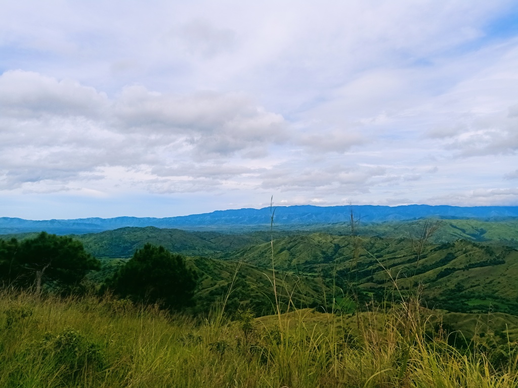
We started the hike at exactly 6 in the morning. The first part of the hike involves paying courtesy to a military detachment half a kilometer away from the jump-off point. Afterwards, we continued through a dirt road which provided us with an awesome view of the Caraballo Mountain Range from left to right. Around 30 minutes or so, the dirt road became surrounded with a lush forest.

An hour into the hike is the end of the long rocky road. We passed through a very short footpath in the middle of a rice plantation, then entered a trail which had a very unique feature—a footpath with a half-a-meter wide waterway canal on the side.
We descended on the left side of the trail towards a river and then crossed it. At the other side of the river is where the ascending trail starts. Here, the slopes were filled with countless pine trees, with the reddish ground covered in grass and dried pine leaves.

In no time, we reached the uppermost part of the slope. Pine trees were scattered around the picturesque area. After snapping a few pictures and having a short rest, we continued walking until reaching what seems to be a campsite.
At this point, one can see in the western direction the mountain range that comprises Mt. 387 and Mt. Lakay in Brgy. Puncan. This mountain range, geographically, is actually the southeastern-most tail of the Cordillera Mountain Range. To its left are other mountains found near the Pantabangan Dam.


On the opposite side of the view at the eastern direction are the forested mountain slopes that are adjacent to Mt. Kasahingan. These heavily-forested slopes are way higher than Mt. Kasahingan and upon checking in my STRAVA map, stand at around 1500-1700+ MASL. At the bottom of these unnamed, unexplored mountains, one can have a small peek of the Mother Falls, one of the highlights of this hike.

After taking some pictures and resting by the pine tree-filled surroundings, we continued the hike and approached the slope of the adjacent higher mountain. This was probably the most scenic part of the hike. Pine trees were scattered everywhere and a good portion of the trail was runnable. The trail was mostly rolling with a mixture of ups and downs. We then entered a forested trail and took a rolling path. This trail eventually leads to the first waterfall in the hike (Falls 1). Afterwards, we descended until reaching another wide waterfall, which they call Falls 3.
Instead of going directly to Falls 3’s lagoon below, we climbed some boulders at the side of that waterfall and negotiated a very narrow path en route to what they call the Mother Falls, the tallest and the most thunderous waterfall of the entire area. To our right is a gushing river that comes from the Mother Falls and is the source of water of Falls 3. Seems like Falls 3 is the first tier waterfall and the Mother Falls is second tier. After a short distance, we descended towards the base of the Mother Falls (Falls 2) via a slippery roped boulder. This waterfall was tall, a wee bit shorter than Mt. Damas’ Ubod Falls, but the water that gushes from it is really strong and thunderous.

We stayed at the boulders on the side of the base of the falls for more than an hour while munching on trail snacks. The entire area is surrounded by a wall of boulder, imprisoning the base of the waterfall. The only way to and from the base is through the trail that we passed through or the gushing river that flows to Falls 3. Nobody dared to swim since the current was strong and the basin seems to be very deep.
We then went to the base of Falls 3 by negotiating again the very technical trail. We decided to stay longer and swim at the base of Falls 3 since the waters there were shallower.

We decided to return to the jump-off an hour after we stayed at Falls 3. Instead of returning to the pine tree slopes, we followed the river from Falls 3. This trail involves climbing through the boulders scattered along the river. Guides are a must here since the trail is almost nonexistent and obscured by plants and trees at the side of the river.

We then passed by Falls 4 where a water source is located. After snapping some photos and refilling our bottles, we ascended on a very technical trail which led to another series of following the river and hopping on large boulders.
Afterwards, we ascended at the side of the trail where the path becomes flat and easy. This trail emerges to the trail with a waterway canal that we took earlier, which meant we circled the area, forming a loop trail!


When we reached the long rocky road, I decided to trail run (wow, runnerist yarn?) a good portion of the path. I reached the barangay hall of Burgos at around 2:30 in the afternoon, completing the entire loop in more than 8 hours! We then bathed at the comfort room establishments of the barangay hall and left at around 4 in the afternoon. As we were exiting Brgy. Burgos, we had a clearer view of the mountains surrounding the entire area. It was such a magnificent sight to behold!
The Caraballo Mountain Range is an untouched area for most hikers but is filled with many high peaks and thick forests. Being flanked by the Sierra Madre to the east and the Cordilleras to the west, this mountain range offers a unique experience that combines the characteristics of both areas—pine trees and rain forests. If the universe permits, these mountains in Brgy. Burgos hopefully get further explored and be taken care of by outdoor enthusiasts someday.

Itinerary
Day 0
09:00 Meet-up, ETD Carranglan, Nueva Ecija
Day 1
06:00AM Start hike
07:30AM Pine tree area, take pictures and rest
09:30AM Resume hike
10:30AM Mother Falls
11:30AM Falls 3
12:30PM Resume hike
02:30PM Jump-off
